×
Pila do ek Chai? | छोटी सी मदद? ☕

If you like our notes, please support the creator!

NotesLover UPI QR

UPI ID: sa786bh@okaxis

Official NotesLover Support

"Padhai toh hoti rahegi, par bina Chai ke dimag ki batti kaise jalegi?" 💡

Aapki help se hum aur bhi FREE notes bana payenge.
Your small contribution keeps us motivated to create more!

Support via UPI (कोई भी राशि) 🚀

Last Updated: Mar 25, 2026

Uploaded By: NotesLover

COMMON NOTES

0 Likes


14 Views


111 Pages


Free


0 Ratings

Indian Geography (भारत का भूगोल) Full Handwritten Notes PDF Download

Download high-quality Indian Geography (भारत का भूगोल) Handwritten Notes PDF. This comprehensive guide covers India's location, IST, boundaries, and the Tropic of Cancer with topper-verified tips and simplified diagrams for competitive exam revision. Read more >
Can't find your notes? We'll provide them for free!
(नोट्स नहीं मिल रहे? हम फ्री में देंगे!)


NotesLover provides free educational notes for learning purposes only. Content owners may request removal. Click Here.

NotesLover केवल शैक्षणिक उद्देश्य के लिए निःशुल्क अध्ययन सामग्री प्रदान करता है। यदि आप सामग्री के स्वामी हैं और किसी भी सामग्री को हटवाना चाहते हैं, तो यहाँ क्लिक करें

Preview Mode: The preview below shows limited pages only. To access the complete document, please click the "View Full PDF" button located just below this box.
नीचे दिए गए प्रीव्यू में सीमित पेज ही दिखेंगे। पूरे नोट्स के लिए इस बॉक्स के ठीक नीचे दिए गए "View Full PDF" बटन पर क्लिक करें।
Share Ratings Report

Introduction: The Study of Our Land

Geography is more than just maps; it is the "Description of the Earth." For any competitive exam aspirant, understanding Indian Geography (भारत का भूगोल) is the foundation of General Studies. These notes simplify complex spatial data into easy-to-remember points, focusing on India's global position and physical identity.

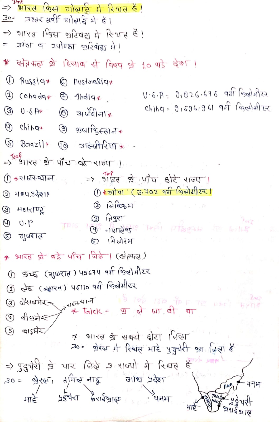
1. Nomenclature (भारत के नाम)

India has been known by several names throughout history, each reflecting a different cultural era:

  • Aryavarta: Named after the Aryans who settled here.
  • Bharat: Named after the powerful King Bharat.
  • Hindustan: Coined by Persians (Iranians) who referred to the land beyond the Indus.
  • Jambudweep: Mentioned in the Puranas and Buddhist literature (बौद्ध काल).

2. Size, Shape, and Location

India is located in the Northern-Eastern Hemisphere. It has a unique Quadrilateral (चतुष्कोणीय) shape that defines its vast borders.

Total Area: $3,287,263$ sq km
World Area Share: $2.4\%$
Global Rank: 7th Largest Country
Feature Measurement
North to South Distance $3,214$ km
East to West Distance $2,933$ km
Latitudinal Extent $8^{\circ}4'$ N to $37^{\circ}6'$ N
Longitudinal Extent $68^{\circ}7'$ E to $97^{\circ}25'$ E

3. IST & The Tropic of Cancer

Two major imaginary lines define India's time and climate. The Indian Standard Time (IST) is calculated from $82^{\circ}30'$ E, passing through Mirzapur.

Quick Fact: IST is exactly $+5$ hours $30$ minutes ahead of Greenwich Mean Time (GMT).

The Tropic of Cancer (कर्क रेखा)

Passing through the middle of India ($23\frac{1}{2}^{\circ}$ N), it crosses 8 states: Gujarat, Rajasthan, MP, Chhattisgarh, Jharkhand, West Bengal, Tripura, and Mizoram.

4. Neighboring Countries & International Borders

India shares its land border with 7 countries. The total land boundary is approximately $15,106.7$ km.

  • Longest Border: Bangladesh ($4,096.7$ km).
  • Shortest Border: Afghanistan ($106$ km).
  • Radcliffe Line: India-Pakistan Border.
  • McMahon Line: India-China Border.

Get the Full Handwritten PDF

Download the complete, high-quality Indian Geography Handwritten Notes PDF. These notes include detailed maps, 7 sisters info, and coastal state data.

Download PDF Now

File Type: PDF | Topic: Indian Geography for UPSC, SSC, and State Exams

Quick Revision:
  • The IST and Tropic of Cancer intersect in Chhattisgarh.
  • There are 9 coastal states in India.
  • Sikkim is not part of the '7 Sisters'.

Frequently Asked Questions (FAQ)

Q: Which state has the longest coastline?

A: Gujarat has the longest coastline in India, followed by Andhra Pradesh.

Q: What is the significance of the 82°30' E longitude?

A: It is the standard meridian of India used to determine the Indian Standard Time (IST).

Q: Through which district does the IST line pass?

A: It passes through the Mirzapur district of Uttar Pradesh (near Prayagraj).

Indian Geography Handwritten Notes Bharat ka Bhoogol UPSC Study Material Geography PDF

Reviews

No review available.

To leave a comment, please log in.

Log in to Comment

© 2026 Notes Lover. All rights reserved.

Back to top